
10 of the Best Hikes Near Oslo, Norway
You don’t need to go far from the city of Oslo to go hiking in Norway!
One of my favorite things about Oslo is how accessible the nearby nature is, especially by public transportation. There are plenty of options for day hikes, even if you are staying in the metropolitan area. This post lists some of the best hikes near Oslo, Norway.
Table of Contents
Best hikes near Oslo
Let’s get started with my favorite day hikes in Oslo!
1. Vettakollen viewpoint
Vettakollen peak is famous for its spectacular views of Oslo and the Oslo fjord! It’s easily accessible by public transportation and an enjoyable hike that can be completed in just an hour or two, depending on how much time you want to spend at the top.


The best months to hike this trail are April through November – there is a decent amount of elevation gain, and the trail can get slippery in the winter. For more details on hiking to the Vettakollen viewpoint, check out this post.
Time and distance:
In total, this out-and-back trail is 3.3 km long. It is estimated to take about 1 – 1.5 hours, but you might want to stop at the top for a bit to enjoy the view!
Directions:
To get to the trailhead, take metro 1 to Vettakollen station and walk up the hill past the pizza place. Then, follow the trail signs for Vettakollen. The trail can also be found in Google Maps if you search for Vettakollen Viewpoint and in AllTrails here.
2. Sognsvann loop
The trail around Sognsvann lake is one of my favorite places to get outdoors in Oslo and very scenic, so I had to include it in this list!

Many Oslo residents go to Sognsvann to run, walk, swim, or picnic, especially on the weekends. In the winter, you might even see someone ice-bathing in the frozen lake!
Time and distance:
The loop around Sognsvann lake is 3.2 km and takes about an hour to walk.
Directions:
Sognsvann can be easily reached via metro 5 – just get off at the Sognsvann stop and follow the main path to the right past the parking lot. Then, continue on the trail that circles the lake.
3. Grefsenkollen
Grefsenkollen is another one of the best hikes near Oslo. The Grefsenkollen hike provides great views of Oslo city and fjord, Holmenkollen, and the surrounding forest. At the top, you can stop to enjoy some lunch at Grefsenkollen Restaurant!

For more details on hiking Grefsenkollen, check out this post.
Time and distance:
This hike is an out-and-back trail that is 3.1 km each way and should take about 1 – 1.5 hours, though there is also a bus stop near the top if you only want to hike one way.
Directions:
To get from Oslo city center to the trailhead for Grefsenkollen via public transportation, take bus 31 (Grorud T) from Jernbanetorget and get off at the Årvoll senter stop. From there, switch to bus 25 (Majorstuen) and get off at Grefsenkollveien.
4. Bygdøy peninsula
Bygdøy is the small peninsula west of downtown Oslo. It features a popular walking trail that is well-marked and takes you along the waterfront of Oslo Fjord.

The trail passes by the royal farm and several of the great museums and beautiful beaches that Bygdøy is known for. To learn more about the attractions on Bygdøy, check out this post.
Time and distance:
The walking trail is 6.5 km in total and should take a couple of hours, but I highly recommend stopping along the way to explore some of the attractions Bygdøy has to offer!
Directions:
To get to Bygdøy, just take Bus 30 from the city center. You can get off at Kongsgården or any stop after it.
5. Mellomkollen
Mellomkollen is a longer hike that some have reported is quite difficult for beginners, so keep this in mind if you go! At the viewpoint on top of Mellomkollen, you can stop for beautiful views of Oslo and the surrounding area.
Time and distance:
This loop trail is 12.3 km in total and takes about 5 hours to hike.
Directions:
To get to the trailhead, take bus 54 (Kjelsås) from Jernbanetorget to Godals vei. Once you arrive, switch to bus 51 (Maridalen) and get off at Skar.
6. Frognersetern
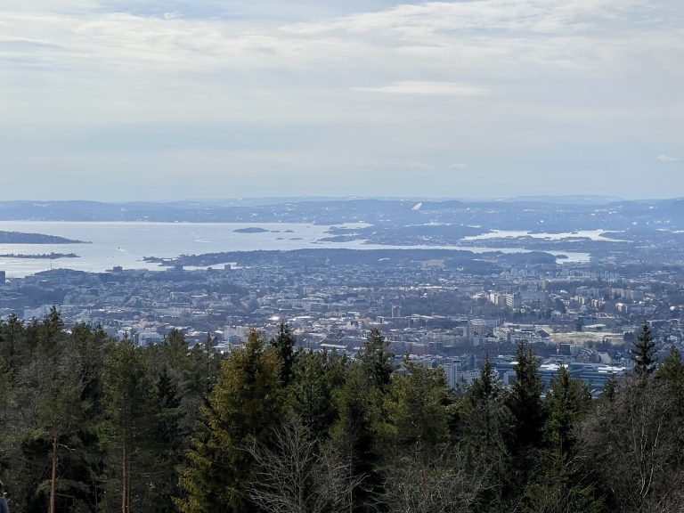
Frognerseteren is another one of the best hikes near Oslo! There are metro stations at either end, so there is no need to hike back the way you came!
Most people hike from Frognerseteren to Sognsvann, but the hike can be done in either direction. The Frognerseteren metro stop offers quite a nice view of Oslo Fjord.

Time and distance:
This hike is 10.4 km in total and takes about 4 to 5 hours to hike.
Directions:
You can get to this hike by taking the metro to either the Frognerseteren stop or the Sognsvann stop. Since the Songsvann stop has a lower elevation, there will be more uphill walking if you start there, but the trail is not very steep.
7. Kolsåstoppene
Kolsåstoppen peak offers panoramic views of Oslo, Bærum, and the Oslo fjord! It is a great option for a slightly longer hike.
Time and distance:
This 8-km hike should take around 4 hours round-trip.
Directions:
To get to the trailhead, take Bus 150 from Bærums Verk or Bekkestua to Stein Gård.
8. Lysaker River
This route takes you along the entire Lysaker River – all the way from the river’s source, Bogstadvannet, to the mouth of the Lysaker Fjord, which is part of Oslo Fjord. This route has several waterfalls, the most notable being the one near downtown Lysaker.
Time and distance:
This 8.3-km hike should take around 4 hours to hike.
Directions:
To get to Bogstadvannet, take the metro to Røa, then transfer to Bus 32 and get off at Bogstad Camping.
9. Maridalsvannet loop
This trail lets you enjoy scenic views of Maridalsvannet lake. It is pretty long, but there are plenty of picnic tables and places to stop for a break along the eastern side of the loop.

Time and distance:
The entire loop is 13.7 km and takes about 3.5 hours, but there is a bus stop about halfway (Kirkeby) if you want to do less.
Directions:
To get to the beginning of the trail, take bus 25 to Kjelsåsalléen and then head north along Midtoddveiein.
10. Nøklevann loop
The path around Lake Nøklevann is another popular and scenic hiking trail in Oslo. It is best to hike this trail between April through October – although cross country skiing is possible in the other months. There is a cafe near the latter part of the trail called Rustadsaga sportsstue, which is a great place to stop for a coffee or a bite to eat!
Time and distance:
This 8.5-km loop generally takes between 2 and 2.5 hours to complete.
Directions:
Take the metro line 3 (towards Mortensrud) to the Ulsrud stop. From there, it is about a 20-minute walk to the trailhead, which you can find by putting “Østmarksetra utfartsparkering” into your maps app.
…
Helpful resources
- You can use the Ruter app to plan your public transport journey around Oslo.
- See the DNT website for more information on hiking in Norway.
- Don’t forget to be a responsible hiker and follow the Leave No Trace principles!
…
I hope you found this list of the best hikes near Oslo helpful!
For more to do during your trip to Oslo, check out this list of the best free things to do in Oslo and this list of the best museums in the city.